
The Monsoon
The monsoon is not a rainstorm, nor is it simply a wet season. It is a seasonal reversal in atmospheric circulation, driven by the different rates at which land and ocean heat and cool, and it delivers the majority of a subcontinent’s water supply in roughly four months. Everything downstream of that, planting, reservoirs, electricity, food prices, rural credit, and a good deal of political fortune, is timed against it.
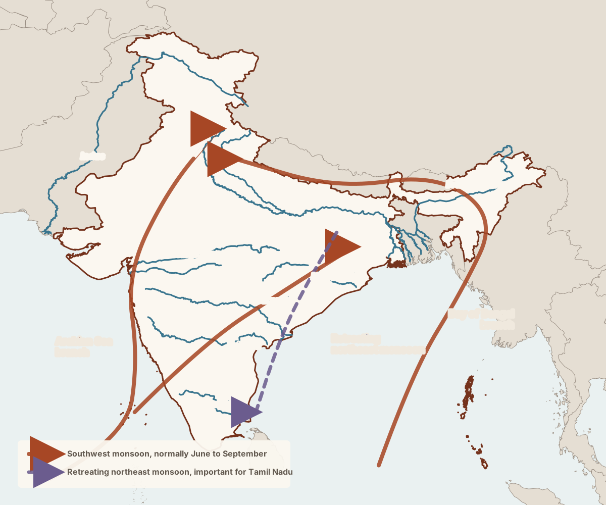
The mechanism
Through spring, the landmass of South and Central Asia heats faster than the surrounding ocean. Air rises over the heated interior, pressure falls, and moist air is drawn in from the sea. Because the earth rotates, that inflow is deflected, and southwesterly winds carry water vapor from the Indian Ocean across the subcontinent. In winter, the process reverses: the interior cools faster than the ocean, and the flow turns offshore and dry.
The heating of the Tibetan Plateau, the position of the upper-atmosphere jet stream, and the seasonal migration of the belt of tropical convergence all shape the timing and strength. The simple land-sea contrast is the right first explanation and an incomplete one, which is why forecasting the monsoon remains difficult after a century and a half of trying.
Two branches, two monsoons
The southwest monsoon normally reaches the Kerala coast around the start of June and advances across the country over the following six weeks, reaching roughly mid-July. It splits around the peninsula into an Arabian Sea branch and a Bay of Bengal branch.
The Arabian Sea branch hits the Western Ghats almost perpendicular. Forced upward, the air cools and dumps enormous rainfall on the windward slopes and the coastal strip, which is why Kerala and coastal Karnataka are wet, and the Deccan interior immediately behind the same hills is dry. That rain shadow is the single most important fact about peninsular agriculture.
The Bay of Bengal branch travels up the coast, is turned northwest by the Himalayan wall, and delivers rain up the Gangetic plain toward Punjab. Where it is forced against the hills of the Northeast, it produces the wettest recorded places on earth, in the Khasi hills of Meghalaya, around Cherrapunji and Mawsynram.
Withdrawal begins in the northwest around mid-September and works its way back down the country. As it retreats, the winds reverse and cross the Bay of Bengal, picking up moisture and delivering it to the southeast coast. This northeast monsoon, from roughly October to December, is a minor event for most of India and the main rainfall season for Tamil Nadu and coastal Andhra Pradesh. A country-level report of a good monsoon can therefore coincide with drought in Chennai.
Rain is not distributed by need. The northwest desert receives very little, the Ghats and the Northeast receive extraordinary amounts, and much of the Deccan sits in a semi-arid middle where the difference between a normal year and a deficient one is the difference between a crop and no crop.
Why the average is misleading
The Meteorological Department reports the seasonal total relative to a long-term average and classifies a season as normal within a few percent of the long-term average. That headline conceals nearly everything that matters.
What matters at ground level is timing and distribution: whether the rain falls when the seed is in the ground, whether there is a long break in the middle of the season, and whether the total falls in a few extreme days or is spread across many moderate ones. A district can receive its normal seasonal rainfall in three catastrophic downpours, lose its crop to flooding, and still appear entirely unremarkable in the national figures.
That distinction is not academic, because it is the part that is changing. The research consensus points to a rise in heavy and extreme rainfall events across much of the country, with the number of rainy days flat or declining, so the same water arrives in a more damaging form. Warming also increases the amount of moisture in the air, raising the likelihood of extreme events. The behavior of the seasonal total under warming is less settled, and claims that the monsoon is simply weakening or simply strengthening tend to outrun the evidence.
Forecasting, and a famous accident
The India Meteorological Department was established in 1875, in the aftermath of famines whose severity was tied to monsoon failure, and forecasting the monsoon was its founding purpose. That effort produced one of the more consequential accidents in the history of climate science.
Gilbert Walker, appointed to lead the department early in the twentieth century, went looking for pressure patterns worldwide that might correlate with the strength of the Indian monsoon. He identified a seesaw in atmospheric pressure across the Pacific, which he named the Southern Oscillation. Decades later, that pattern was recognized as the atmospheric half of El Niño, and the coupled system is now the single most important source of seasonal predictability worldwide. It was founded by a colonial meteorologist trying to warn India about drought.
El Niño years are associated with a higher likelihood of a weak Indian monsoon, though the relationship is a tendency rather than a rule and has weakened in some decades. The Indian Ocean Dipole, a comparable east-west temperature seesaw in the Indian Ocean, exerts its own influence and can partly offset an El Niño. Forecast skill has improved, particularly with dynamical models run at higher resolution, and remains modest for what farmers actually need: what will happen in their district over the next fortnight.
What depends on it
Agriculture is the obvious dependent, and about half the country’s cropped area is unirrigated and therefore directly exposed. The kharif crop is sown at the onset and harvested after the monsoon; the rabi crop that follows in winter depends on residual soil moisture and on reservoirs and groundwater replenished by the monsoon. A failed monsoon therefore damages two seasons.
Beyond the fields: hydroelectric generation and thermal plant cooling both depend on water levels; urban supply depends on reservoirs filled in a few months; food price inflation follows crop shortfalls with a lag; and rural demand for everything from motorcycles to gold moves with the harvest. The Reserve Bank of India watches the monsoon because it moves inflation, and governments watch it because rural distress is electorally expensive.
The state’s response has changed the exposure without removing it. Irrigation, buffer grain stocks, the public distribution system, crop insurance, and rural employment guarantees mean that a bad monsoon in India now produces hardship and debt rather than the mass mortality it produced under colonial administration in the 1870s and 1890s. That is a real achievement of the republic, and it is not the same as independence from the rain.