
Geography
India is often pictured as a triangle hanging below the Himalayas. That gets the silhouette right and much else wrong. The country is a collision zone, a river plain, an ancient plateau, a desert, two long coasts, two island chains, and a northeastern region attached to the rest by a corridor only a few dozen kilometers wide at its narrowest point. Geography does not determine Indian history, but it sets nearly all of its terms.
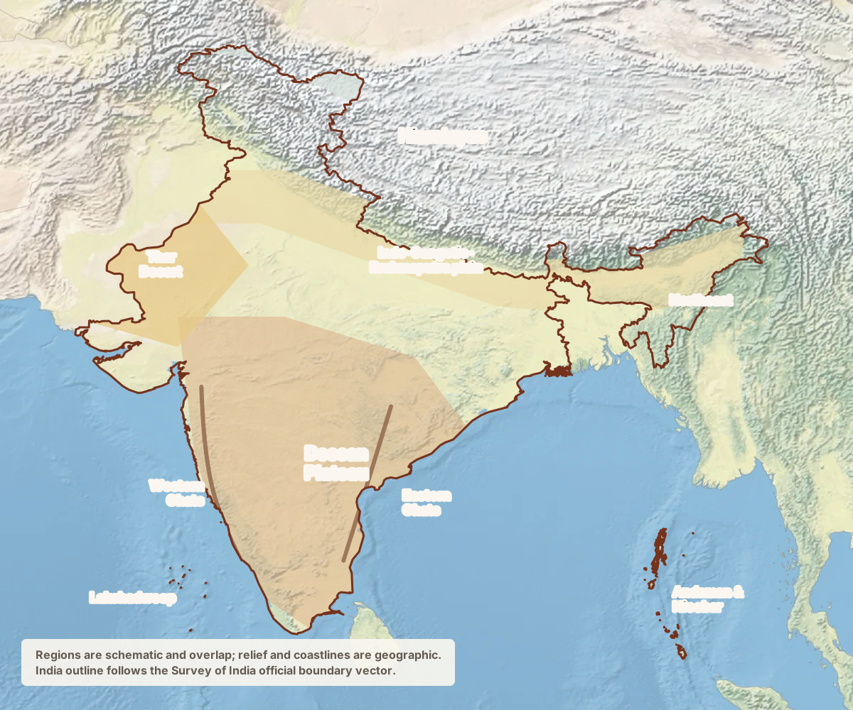
Three large structures
The Himalayas are geologically young, still rising as the Indian plate pushes into Eurasia, and continue to produce earthquakes. They arc from Ladakh through Himachal Pradesh and Uttarakhand to Sikkim and Arunachal Pradesh. They are not an impassable wall: armies, traders, pilgrims, pastoralists, and refugees have crossed their passes for millennia. But the range redirects weather, feeds the great northern rivers, and creates a frontier shared with Pakistan, China, Nepal, and Bhutan.
The Indo-Gangetic-Brahmaputra plain runs below the mountains from Punjab through the Ganga basin to Bengal and then up the Brahmaputra valley in Assam. River sediment built some of the most fertile and densely settled land on earth. The same rivers also flood, change course, erase villages, and deposit new land somewhere else. Much of the political history of northern India is a history of states trying to command this plain and the revenue it could produce.
The peninsular plateau is much older. The Deccan sits on hard rock south of the Narmada, bordered by the Western and Eastern Ghats and cut by rivers that flow mostly eastward toward the Bay of Bengal. The plateau contains much of India’s coal, iron ore, bauxite, and forest, which is also why mining, dams, conservation, and Adivasi land rights collide there so often. Along its western edge, the Ghats intercept the monsoon and produce a wet coastal strip beside a much drier interior.
These structures leave out important margins: the Thar Desert and salt flats in the west; the Kashmir valley; the marshes and mangrove delta of the Sundarbans; the high, wet hills of the Northeast; and the Lakshadweep and Andaman and Nicobar island chains. The islands put India deep into the Arabian Sea and Bay of Bengal rather than merely at their edge, and the Andamans lie closer to Southeast Asia than to the Indian mainland.
Regions that resist the labels
“North India” usually means the Hindi-speaking belt and sometimes everything north of the Deccan, which hides more than it reveals. Punjab, Kashmir, Rajasthan, the Gangetic plain, Bengal, and the Himalayan states have different languages, agrarian systems, cuisines, and political histories. “South India” joins four major language regions that share some historical structures but disagree about plenty. Western India links the commercial coast to Rajasthan and the Deccan; eastern and central India contain both old agrarian heartlands and the mineral-rich Adivasi belt.
The Northeast breaks the standard map most completely, which is why it has its own page rather than a paragraph here.
A more useful way to read the physical map is by what it constrains. Where the rain falls decides what is grown and when, so the monsoon is the country’s governing clock. Where the water is stored, moved, and fought over shapes both federal politics and foreign policy, which is the subject of rivers and water. Where people move to work and where they keep going home to explain the shape of cities and migration. The coasts, islands, and the Indian Ocean turn the edge of the land map into a maritime center. What all of this is doing to the air, forest, groundwater, and heat is the environmental argument. And the lines around the edges, several of which are not agreed borders at all, are their own subject.
The pages below take each of those in turn.
-
The Monsoon
Not a rainstorm and not a season, but a reversal in circulation that the whole country’s agriculture, electricity, and politics are timed against.
-
Rivers & Water
Infrastructure, ecology, boundary, and deity in the same stretch of water, which is why there is no purely technical water policy.
-
The Northeast
Eight states attached to the rest of the country by a corridor a few dozen kilometers wide, and the place where the standard map of India breaks.
-
Coasts, Islands & the Indian Ocean
Two very different mainland coasts, coral and volcanic island chains, and an ocean that has connected the subcontinent to wider worlds for millennia.
-
Cities & Migration
A country that is officially a third urban, actually more than that, and held together by workers who never quite finish moving.
-
Environment
Air, groundwater, heat, and forest, and the fact that the argument is rarely developed against nature in the abstract.
-
Borders
A line drawn in five weeks, a ceasefire line that became a frontier, an undemarcated border in the mountains, and enclaves that took sixty-eight years to swap.