
Coasts, Islands & the Indian Ocean
India is conventionally drawn as a landmass tapering into the sea. That view makes the shore look like an edge. For fishers, sailors, port workers, island communities, and merchants, it has more often been a working landscape: a place of routes, tides, estuaries, reefs, storms, and exchange. The western and eastern coasts differ in geology and river systems; Lakshadweep and the Andaman and Nicobar Islands belong to entirely different physical worlds. Together, they extend India’s inhabited and political geography far into the Indian Ocean.
How long is a coastline?
For decades, official publications listed India’s coastline at 7,516.6 kilometers, including the mainland and islands. A reassessment using a more detailed digital shoreline and a standardized high-water line raised the official total to 11,098.81 kilometers in 2025. The older number was not a straight line, and the new number does not mean India acquired a new coast. Higher-resolution mapping follows more inlets, creeks, bays, and island edges. A jagged boundary grows longer as the measuring unit becomes smaller—the practical form of what is often called the coastline paradox.
The revision illustrates why geographic statistics need their method and date attached. It also, by itself, does not move state boundaries or the regulated coastal zone. Nine states and four Union Territories meet the sea, but their shares depend on which islands and tidal features are counted and at what scale.
Two mainland coasts
The western coastal plain lies between the Western Ghats and the Arabian Sea. It is generally narrow, though it widens in Gujarat and around river valleys. Short, steep rivers descend from the Ghats; many meet the sea through estuaries rather than building large deltas. Drowned valleys and sheltered inlets helped create harbors, while the Kerala backwaters form a linked landscape of lagoons, canals, lakes, fields, and settlements. The southwest monsoon reaches this coast first and rises sharply over the Ghats, producing some of India’s heaviest seasonal rain.
The eastern coastal plain is generally broader. The Mahanadi, Godavari, Krishna, and Kaveri carry sediment across them and have built large, densely settled deltas. The Bay of Bengal supplies the heat and moisture that fuel powerful tropical cyclones, which can drive storm surges onto low-lying coasts and deltas. The contrast is not absolute: Gujarat and the Sundarbans are tidal worlds of creeks and mudflats; both coasts have lagoons, ports, beaches, mangroves, and stretches that erode or accumulate over time.
These landforms shape settlement. A delta may offer fertile alluvial soil and irrigation while exposing homes and crops to saltwater and flooding. An estuary may shelter a port while concentrating industrial discharge. A beach can be a tourist amenity, a turtle nesting site, a storm buffer, and a launch point for fishing boats at once. “The coast” is therefore not one strip with one economic purpose.
Ports and maritime worlds
Indian Ocean sailing long predated European empires. Seasonal wind systems helped vessels move between ports on the subcontinent, in the Red Sea and Persian Gulf, in East Africa, in Sri Lanka, and in Southeast Asia. Roman-era finds, inscriptions, ceramics, shipwrecks, and literary accounts reveal trade without describing one continuous, centrally controlled system. Pepper, textiles, horses, aromatics, grain, metals, and people moved through changing networks in which coastal rulers, merchant communities, and inland producers all participated.
Ports shifted when rivers silted, dynasties changed, or commercial routes moved. The Portuguese Estado da Índia, Dutch and English companies, and other European powers tried to tax or monopolize parts of maritime commerce. Still, they entered an ocean already crowded with Gujarati, Tamil, Arab, Persian, Malay, Chinese, and other traders. Under British rule, Bombay, Calcutta, and Madras became imperial port cities connected to railways and export hinterlands. Their growth reorganized older ports rather than beginning Indian maritime history.
Modern ports handle petroleum, coal, containers, fertilizer, vehicles, and bulk commodities. They also consume land and alter sediment, wetlands, fishing access, and nearby settlements. A harbor presented as national infrastructure may be experienced locally as a change in currents, a longer trip to the fishing ground, or the loss of a landing beach.
Lakshadweep: land made by reefs
Lakshadweep comprises 36 islands, including 12 atolls, with only 10 inhabited. Its land area is about 32 square kilometers, but its lagoons cover roughly 4,200 square kilometers. The disparity matters: reef, lagoon, and open sea sustain settlement far more than the tiny dry-land figure suggests. The islands are low coral formations built over a submerged volcanic ridge. Fresh water is limited, soils are thin, and the reef helps break ocean waves. Damage to coral or changes in sediment movement can therefore affect both the ecology and the physical persistence of an island.
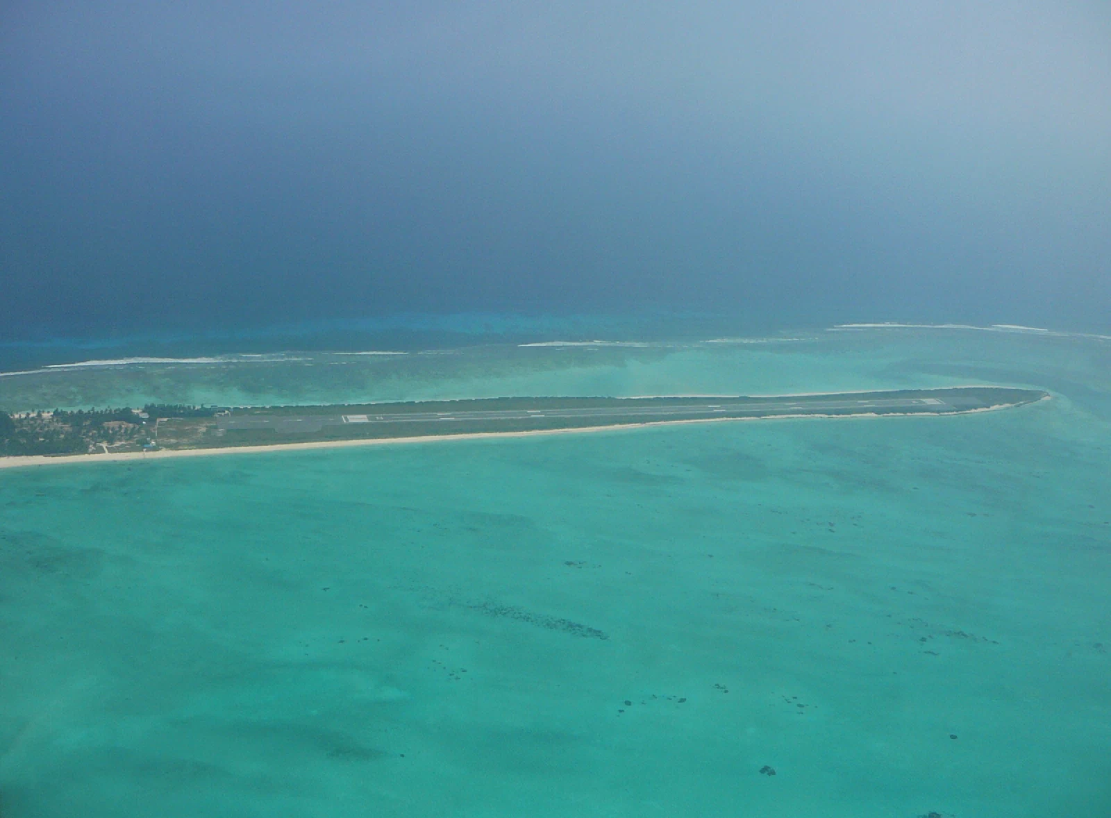
Most residents are Muslim, and Malayalam and Jeseri are widely spoken; Mahl is spoken on Minicoy, which is located farther from the mainland and has historical ties that set it apart within the archipelago. Coconut cultivation, tuna fishing, government employment, transport, and regulated tourism support the economy. Ships and aircraft are lifelines rather than conveniences. Decisions about visitor numbers, land leases, waste, reefs, and construction are consequently arguments about who bears the ecological risk and who controls scarce space.
The Andaman and Nicobar chain
The Andaman and Nicobar administration counts 836 islands, islets, and rocky outcrops, of which only a small minority are inhabited. The chain is a continuation of the tectonic arc that runs from Myanmar to Indonesia. Barren Island is home to India’s only confirmed active volcano, while Narcondam is volcanic but not known to be active. The islands sit closer to parts of Southeast Asia than to much of mainland India and command approaches between the Bay of Bengal and the Malacca Strait.
The archipelago is not an empty strategic outpost. Great Andamanese, Jarawa, Onge, Sentinelese, Shompen, and Nicobarese communities have distinct histories and relationships to land, sea, and outsiders. The colonial penal settlement, especially the Cellular Jail, brought together prisoners and administrators; later migration produced a diverse settler population. Protection regimes restrict access to some Indigenous reserves, but disease, encroachment, infrastructure, tourism, and the very act of outside observation remain threats. North Sentinel Island is protected, and attempts to contact its inhabitants violate both the law and their demonstrated choice to remain isolated.
On 26 December 2004, a massive undersea earthquake off the coast of Sumatra generated a tsunami across the Indian Ocean. The Nicobar group was especially devastated; some land subsided while other areas rose. The disaster showed that island vulnerability is not merely a matter of distance from the mainland. It is the conjunction of tectonics, coast shape, transport, communications, housing, and whether warnings can reach people in time.
Ocean territory, coastal responsibility
India’s exclusive economic zone covers roughly 2.4 million square kilometers. Within it, the state has rights over resources and certain economic activities, not full sovereignty equivalent to land territory. The islands contribute disproportionately to this maritime jurisdiction, which helps explain their growing strategic prominence. Fisheries, offshore energy, seabed research, naval operations, shipping security, and marine conservation all meet there.
That strategic view can flatten inhabited places into dots on a map. Coastal regulation, in contrast, has to reconcile ports, housing, defense, tourism, aquaculture, salt pans, wetlands, and fishing. Mangroves and dunes reduce some storm impacts; reefs support fisheries and blunt waves; estuaries are nurseries for marine life. None is an absolute shield, and protection cannot mean removing traditional users while allowing larger projects through exceptions.
Sea-level rise raises the baseline from which tides and storm surges act. Warmer seas can intensify the rainfall associated with tropical cyclones, while marine heatwaves damage coral. At the same time, dams reduce sediment reaching some deltas, groundwater extraction can cause land subsidence, and seawalls may shift erosion downshore. Climate change is therefore not a single future event affecting a natural coast. It amplifies pressures already produced by settlement and engineering.
To see India from the ocean is to reverse the usual map. The peninsula becomes a platform between sea routes; rivers become connections from hinterland to port; and remote islands become homes at the center of a maritime region. The shore is not where geography ends. It is where several geographies meet.